The Lawlyes Log

The Lawlyes Family experienced a lot of changes in the last year. Last December our first grandchild, Benjamin was born to Becky and Matt, becoming the new center of our universe. Sara graduated from law school and relocated to Long Beach, CA and is working for the U.S. Air Force. Carolyn and Larry retired and moved to Prescott, AZ. Staying in touch with each other and our friends is a challenge and a priority. This log will help us share the new unfolding chapters of our lives.

My Photo
Name:
Location: Prescott, Arizona

Friday, April 20, 2007

Canyon de Chelly

Northeastern Arizona is Navajo Land, home to 174,000 Native Americans. The Navajo Nation, a sovereign territory, encompassing 27,000 square miles across Arizona, New Mexico, and Utah, is larger than 10 states. It has some of the most beautiful landscape in the Southwest.


Much of the reservation is open range land. You need to drive carefully.


It is common to see cattle and horses roaming freely and crossing the highway.


Carolyn and I traveled there recently to see Canyon de Chelly (d'Shay) an area sacred to the culture of the Navajo.

Canyon de Chelly is really three canyons, de Chelly, del Muerto, and Monument, cut by streams from mountains to the east. It has been home to Native Americans for 5,000 years.


The canyon is unique in the National Park Service. It is the only site wholly within tribal lands. The park was established in 1931 to preserve the ruins there.


The most famous geological feature of the canyon is Spider Rock, an 800 foot sandstone spire rising above the canyon floor.

The Navajo (they call themselves the Dineh) say the monolith is home to Spider Woman, an important deity in their culture. Spider Woman saved them from monsters when the Dineh emerged in this world.

Elders warn their children that Spider Woman will drop down her web and take them to the top and devour them if they are bad. They say the top is white from the sun bleached bones of naughty children.


To see the canyon, you can drive its north or south rim. To go into it requires a permit and a Navajo guide or you can use the one public access trail.


Carolyn and I hiked into Canyon de Chelly on the White House Trail.


The 2.5 mile trail descends a 500 feet to the canyon floor. (Other parts of the canyon are 1,000 feet deep.)


At the bottom, the canyon floor opens on a plain with a stream, small farmed fields, and grazing land for sheep, cattle, and horses.


On the south facing cliff are ruins of the White House, a cliff dwelling built 1,000 years ago by Puebloans. The white washed walls gave the structure its name.

For unknown reasons, the Puebloans abandoned Canyon de Chelly around 1300. In succeeding centuries the Hopi then the Navajos came to the canyon.

Tuesday, April 17, 2007

The Petrified Forest & The Painted Desert


250,000 years ago Arizona lay near the Equator in a tropical environment. Tall conifer trees grew along rivers. Small dinosaurs lived there with crocodile-like creatures and giant amphipians. Trees fell and were carried away by rivers and buried in silt and volcanic ash. Mud cut off the oxygen and slowed their decay. Silica seeped into the wood and replaced the tissue. It crystallized into quartz petrifying the trees.

Arizona's climate changed. Over the eons, weather wore away the rock strata and exposed fossilized trees and animals.

Today over 200,000 acres in northeast Arizona are designated as The Petrified Forest National Park showcasing this geological phenomena. The park road is 28 miles long.


The park contains one the world's largest and most colorful collections of petrified wood.


Here a petrified log has been cut and polished. Because visitors are keen on having pieces of petrified wood, there are heavy fines for removing them. Many places sell them legally outside the park.
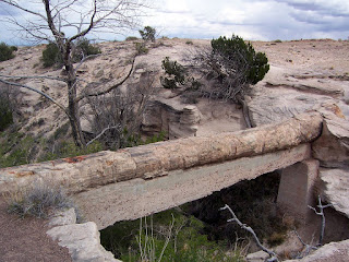
The Agate Bridge. Centuries of erosion of softer surrounding sandstone left this petrified tree a natural bridge. In 1906 conservationists built a support under it. Today's philosophy would leave it as it was and allow nature to takes its course.


Hey, just wanted everyone to know the new diet plan is working great!

Actually this is Placerias, a large plant-eating Triassic Era critter, who roamed Arizona back when these trees were alive and well. His skeleton was found in the Park.


This formation is called The Tepees. These cone shapes get their color from iron, carbon, manganese and other minerals.


Wouldn't it be interesting to know what the first Native Americans thought of the area? We know they used the materials to build houses here 800 years ago. This is the Agate House.
Another indication of habitation of the area is the many petroglyphs. Hundreds are etched in the stone known as Newspaper Rock. (For a closer view, click on the picture.)

At the north end of the Park you arrive at the Painted Desert. It is an expanse of arid and eroded land 160 miles long which extends from the Grand Canyon to the Petrified Forest.

The rainbow colors come from exposed sedimentary layers that contain various mineral deposits. It is a gorgeous austere landscape.

Meteor Crater

50,000 years ago when Northen Arizona was inhabited by wooly mammoths, a meteor about 150 feet across and weighing 165,000 tons slammed into the cool wet grasslands 35 miles east of Flagstaff at more than 28,000 miles per hour. It left an impact crater that today is 4,000 feet across and 570 feet deep.
50,000 years later, Carolyn and I visited Meteor Crater and were quite impressed. Driving across the flat land leading up to it you have no sense of what is to come.

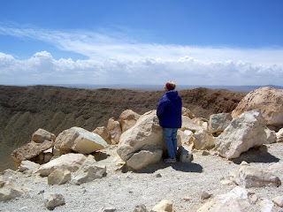
The impact created a rim 150 feet high that hides the crater. (Carolyn is standing on the north rim.)

Only after climbing the rim do you see the immensity below. The energy released by the collision was 150 times more powerful than the bombs dropped on Hiroshima and Nagasaki. Life within 3 miles of the hit was killed instantly. 1200 mph winds were sent out flattening everything for 13 miles in all directions. Life didn't return to the vicinity of the crater for a century.
In 1903, engineer Daniel Barringer first suggested the crater was a meteor impact site. His theory was confirmed in 1960 by Gene Shoemaker. Meteor Crater, the first proven impact crater on Earth, is also the best preserved.

Thursday, April 05, 2007

Vegas

Carolyn had never been to Las Vegas. We made a trip to fill this cultural void. Sara joined us from LA. We saw the Cubs last spring game, visited Hoover Dam and toured the Strip.

I can't tell you everything that happened in Vegas but here is the public version.
I was last in Vegas 25 years ago. What I now saw was nearly all new. Here is the Wynn Hotel, designed by Steve Wynn who also designed the Mirage, Treaure Island and The Bellagio. It was built on the sight of the old Desert Inn.

Here's the Paris Hotel and Casino. The Eiffel Tower is built to 1/2 scale of the original. Notice the Arc de Triomphe next to it.

Italy is also represented. This is the Venetian Hotel complete with ...


Gondolas and singing boatwomen on the Grand Canal! The Venetian Hotel took the place of the legendary Sands Hotel.

You can see the New York skyline without leaving Vegas. Here's the Statue of Liberty, the Empire State Building, the Brooklyn Bridge and a Coney Island roller coaster thrown in.

We watched the pirate ship battle at Treasure Island.


Probably our favorite, however, was The Bellagio with its ...

Incredible fountain show

and its beautiful indoor gardens.

After a 25 year gap, the only landmark I remember from my earlier trips to Vegas was the venerable old Caesar's Palace.

Wednesday, April 04, 2007

Hoover Dam

The best part of our trip to Las Vegas was the Hoover Dam. I was surprised to be so impressed. The dam is 726 feet high and 1244 feet wide at the top. It was built 1931 - 1935.


I was glad to get to drive across it. In a few years a bridge to bypass it will be complete and traffic will no longer be allowed on the dam itself.


The bypass is being built to save wear on the dam and for security reasons. Homeland Security now conducts vehicle inspections on the Arizona and Nevada sides before they cross over the dam.


Hoover Dam blocks the Colorado River to form Lake Meade.


It controls water flow for states throughout the Southwest.


It generates power for millions in this desert clime.

Lake Meade creates a wonderful recreation area. It draws thousands of new people to the Southwest. In the last 5 years, Meade has dropped 20 feet. How long can the limited water source support unbridled growth?


This sculpture, "The High Scaler" commemorates the thousands of men who worked on the project in the depths of the Depression, often for as little as 50 cents an hour.


Also honored are the many who died during the construction.